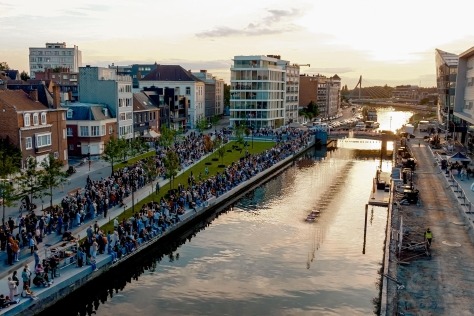
Start of works in Sint-Andries and Zuid sub-area of Scheldt quays


The city and Waterwegen en Zeekanaal NV are jointly starting works in the Sint-Andries and Zuid sub-area of the Scheldt Quays. The city is starting the first phase of the reconstruction of the public domain: a 900-meter area between Goedehoopstraat and Namenstraat. The area behind the historic fence will be completely repaved. The works are part of the reconstruction of the Scheldt Quays. Waterwegen en Zeekanaal NV is starting work on a new flood barrier, as part of the Sigma Plan. The end of the works is scheduled for mid-2019.
Scheldt quays master plan - Quays plan
To restore the connection between the city and the river Scheldt, the Scheldt Quays will be given a new look in the coming years. The Scheldt Quays Master Plan, also known as the Quays Plan, addresses a total of 7 sub-areas. Sint-Andries and Zuid, a 1.5-km strip between Sint-Jansvliet and Namenstraat, is one of them. Among other things, there will be a winding dike with expansive waterfront space for walking, playing and sports. Along the city side will be a long green strip. The design of the public areas of the Sint-Andries and Zuid sub-area was drafted by PROAP and Wit Architecten. The temporary association ArtesStadsbader is carrying out the works.
Start of works for rebuilding the public domain
The reconstruction starts with a first phase of 900 meters, namely the area between Goedehoopstraat and Namenstraat, and consists of several site phases.
- Phase 1: September to November 2017. The parking lot with driveway at Scheldestraat will be moved to a temporary parking lot with driveway ramp at Fortuinstraat. Current parking capacity will be maintained. Hangar 13 on Ledeganckkaai and hangar 15 on Cockerillkaai will be demolished. Hangar 19 on Plantinkaai will be dismantled and recovered. After Phase 1, the area between Goedehoopstraat and Namenstraat will be completely closed as a construction site zone.
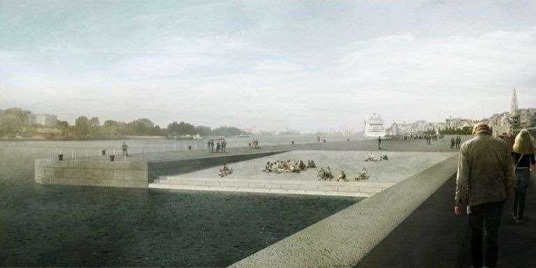
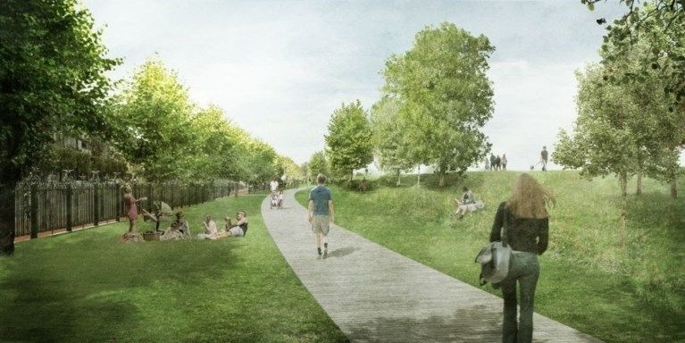
- Phase 2: September 2017 to November 2018. This phase is the most far-reaching and involves the construction of a linear park with embankment, playground, wash and transfer area for sweeping trucks at the level of the Namenstraat, a dog-walking zone, an urban square at the level of the Zuidersluis and the restoration of the harbour fence between the Goedehoopstraat and the Namenstraat. The embankment will be designed as an elongated green park that extends to the quays towards ZuidNieuw Zuid and, in a later phase, forms a green corridor through Blue Gate Antwerp to the Hoboken polder. A walking path will be built atop the embankment, providing a sweeping view of the city and the Scheldt River. The path does not follow a straight line, but passes by various places such as green seating and play areas, seating stands with a view of the Scheldt, multifunctional sports zones, a wide bicycle and walking boulevard and a lookout point close to the river.
- Phase 3: September 2018 to spring 2019. Phases 3 and 4 can only start after Waterwegen en Zeekanaal NV stabilizes the quay wall in this area. The stabilization works are already in full swing today and are expected to be completed in September of 2018. Phase 3 consists of the construction of the quay plain (the area between the embankment and the existing Blauwe Steen) and an urban beach on Cockerillkaai between Wapenstraat and IJzerenpoortkaai. On the waterfront, the space will retain its maritime character, in part by reusing the existing cobblestones. The existing crane tracks will be preserved and large ocean-going vessels can continue to dock at the bollards along the Blauwe Steen. At the Zuidersluis there will be an inclined plane so that everyone can get close to the water.
- Phase 4: November 2018 to spring 2019.
Construction of the quay area between Goedehoopstraat and Wapenstraat.
Start of flood barrier works
Since the summer of 2014, Waterwegen en Zeekanaal NV has been stabilizing the historic quay wall in the Sint-Andries and Zuid quay area, which no longer meets modern safety standards. Stabilization has since been completed in the first of three sub-areas (between Namenstraat and Zuidersluis). In the area between Zuidersluis and Scheldestraat, stabilization works are currently underway. Between Namenstraat and Goedehoopstraat, Waterwegen en Zeekanaal NV and the city of Antwerp are realizing a beautiful piece of urban renewal including, among other improvements, a parking lot and a green embankment on which everyone can come and stroll. The embankment (the new higher water barrier) replaces the current water barrier - a 1.35-meter-high concrete wall separating the quays from the city - and will further protect the city from flooding.
Unique in Flanders
Project engineer Koen Segher of Waterwegen en Zeekanaal NV: "We are designing the new flood barrier mainly in the green, sloping embankment, which is unique in a Flemish city. The embankment will rise 2.25 meters above the Blauwe Steen quay wall. That height is stipulated in the Sigma Plan and guarantees that the embankment can hold back tidal waves from the Scheldt during storm tides. The walkable embankment is the common thread throughout the Sint-Andries and Zuid quay area. It will not be equally wide or steep everywhere, but meanders through the area, so to speak. The embankment divides the bay area in two. On the Scheldt side, Waterwegen en Zeekanaal NV will preserve the authentic maritime appearance of the quays. In times of extremely high-water levels, the quay plain may be flooded. The raised flood barrier will ensure that the feet of the residents of the St. Andrews and Zuid neighbourhoods remain dry.
Cost
The investment budget for this first phase is 11,295,261.77 euros, including 8,837,905.07 euros by the city and 2,122032.11 euros by Waterwegen en Zeekanaal NV. Rio-Link is investing 335,324.59 euros for the sewerage system.